
Spotting Trouble from Afar: AI Cameras Revolutionizing Wildfire Detection in Minnesota
Spotting Trouble from Afar: AI Cameras Revolutionizing Wildfire Detection in Minnesota
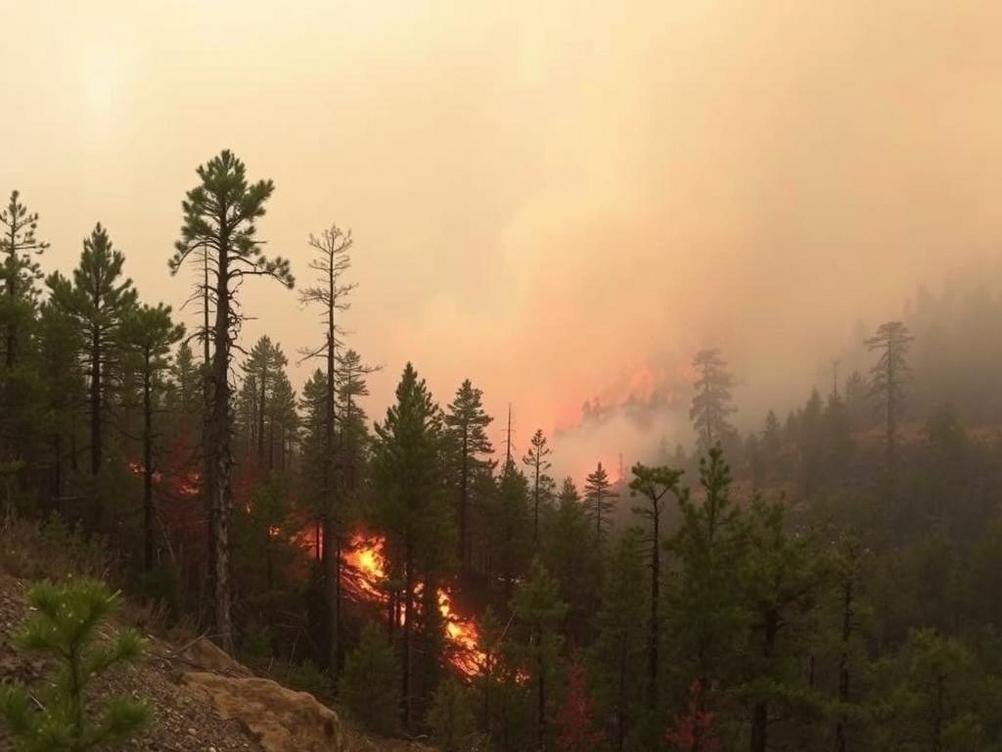
Picture this: you’re hiking through the lush forests of Minnesota, the kind where the air smells like pine and adventure, and suddenly, way off in the distance, a tiny puff of smoke catches your eye. But wait, you’re not the one spotting it—it’s a high-tech camera perched on a hill, powered by artificial intelligence, that’s already alerting firefighters before things get out of hand. That’s the reality kicking off in Minnesota right now, where AI cameras are scanning the skies for the earliest signs of wildfires. It’s like having a bunch of super-vigilant watchdogs that never sleep, eat, or get distracted by squirrels. This tech isn’t just cool; it’s a game-changer in a state where wildfires, though not as infamous as California’s blazes, can still wreak havoc on our beautiful Northwoods. With climate change cranking up the heat—literally—and dry spells becoming more common, early detection could mean the difference between a small brush fire and a full-blown disaster. I’ve always been fascinated by how technology steps in to solve real-world problems, and this feels like something out of a sci-fi movie, but it’s happening here and now. In this post, we’ll dive into how these AI eyes in the sky work, why Minnesota needs them, and what it all means for the future of firefighting. Buckle up; it’s going to be an enlightening ride through innovation and nature’s fury.
What Exactly Are These AI Cameras?
So, let’s break it down without getting too techy—because who wants to read a manual when you can have a chat? These AI cameras are basically smart surveillance systems mounted in strategic spots across Minnesota’s wilderness. They’re not your average security cams; these bad boys use artificial intelligence to analyze live video feeds in real-time. Imagine a camera that doesn’t just record but thinks: it spots smoke patterns, heat signatures, and even unusual movements that might signal a fire starting. Companies like Pano AI or similar outfits are behind this, deploying networks of these cameras that cover vast areas. In Minnesota, they’re being rolled out in places like the Boundary Waters Canoe Area Wilderness, where human eyes can’t possibly monitor every inch.
The magic happens through machine learning algorithms trained on thousands of images of fires and non-fires. It’s like teaching a dog to fetch, but instead, it’s teaching software to yell “Fire!” at the right moments. And get this—these systems can detect smoke from miles away, often before anyone on the ground notices. According to recent stats from the Minnesota Department of Natural Resources, wildfires have burned over 10,000 acres in the state in the past few years, and early detection could cut response times by hours. Isn’t it wild how a bit of code can outsmart Mother Nature’s tantrums?
Why Minnesota? The Wildfire Risks You Might Not Know About
Minnesota might not be the first place that pops into your head when you think wildfires—hello, California and Australia—but don’t underestimate the Land of 10,000 Lakes. Our northern forests are tinderboxes waiting for a spark, especially during drought seasons. Climate change is making things worse, with hotter summers and less snowpack leading to drier conditions. Remember the 2021 Greenwood Fire that scorched nearly 27,000 acres? That was a wake-up call. AI cameras are stepping in to fill the gaps where traditional methods like fire towers and patrols fall short.
Think about it: in remote areas, it could take days for someone to report a fire. These cameras change that by providing 24/7 monitoring. Plus, they’re integrated with weather data, so if winds are whipping up or humidity drops, the system gets extra alert. It’s like having a personal meteorologist and detective rolled into one. I chuckle thinking about old-school fire watchers in towers with binoculars—charming, but let’s face it, tech is taking over, and for good reason. The state is investing in this because prevention is cheaper than cleanup; wildfires cost millions in damages and firefighting efforts.
To put it in perspective, the National Interagency Fire Center reports that human-caused fires make up a big chunk here, from campfires gone wrong to arson. AI doesn’t judge; it just spots and reports.
How Do These Cameras Actually Work Their Magic?
Diving deeper, the tech involves high-resolution cameras with panoramic views, often 360 degrees, scanning the horizon. AI algorithms process the footage, using computer vision to differentiate between, say, a campfire’s smoke and a forest fire’s plume. False alarms? They’re minimized through constant learning—the system gets smarter over time, like a kid learning from mistakes.
Once smoke is detected, alerts zip to command centers via apps or dashboards. Firefighters get coordinates, images, and even predicted fire paths based on wind and terrain. It’s integrated with tools like satellite data for a fuller picture. Ever played with those fire simulator games? This is the real deal, but with stakes higher than a video game score.
And here’s a fun fact: some systems use infrared to see through fog or at night. No more blind spots! In Minnesota, partnerships with tech firms and the DNR are making this a reality, with pilot programs already showing promise in reducing response times by up to 50%.
The Benefits: More Than Just Spotting Smoke
Beyond detection, these AI cameras are lifesavers—literally. They protect wildlife, homes, and those brave firefighters who rush into danger. Early warnings mean evacuations happen sooner, saving lives and property. Economically, it’s a win; the cost of one major fire can dwarf the investment in tech.
Environmentally, quicker responses mean less scorched earth, preserving habitats for moose, wolves, and all the critters we love. Plus, it ties into broader climate strategies. I mean, who wouldn’t want to prevent the kind of air quality nightmares we saw during Canadian wildfires affecting Minnesota skies?
Let’s not forget the data goldmine: these systems collect info on fire patterns, helping researchers predict and prevent future blazes. It’s like turning hindsight into foresight.
Challenges and the Human Touch
Of course, nothing’s perfect. AI can glitch—think false positives from dust storms or barbecues. That’s where humans come in, verifying alerts. It’s a team effort, not a replacement.
Privacy concerns? In wilderness areas, it’s minimal, but as tech expands, we’ll need rules. Cost is another hurdle; setting up networks isn’t cheap, but grants and partnerships are helping. And hey, what if hackers target them? Cybersecurity is key, folks.
Still, the pros outweigh the cons. I’ve got a buddy who’s a volunteer firefighter, and he says this tech could make his job safer. It’s about blending innovation with good old human grit.
Looking Ahead: The Future of AI in Firefighting
As AI evolves, expect drones and robots joining the fray, maybe even AI predicting fires before they start based on data trends. In Minnesota, expansion plans could cover more state parks and rural areas.
Globally, this tech is inspiring similar setups worldwide. It’s a reminder that while wildfires are scary, human ingenuity (with a dash of AI) can fight back. Who knows, maybe one day we’ll have AI preventing sparks altogether.
Conclusion
Wrapping this up, AI cameras scanning Minnesota’s skies are more than gadgets—they’re guardians of our natural treasures. From quick detections to saving resources, they’re reshaping how we tackle wildfires. If you’re out there enjoying the great outdoors, take a moment to appreciate this unseen tech keeping watch. Let’s support these innovations, stay vigilant with our own habits, and maybe, just maybe, keep those forests green for generations. After all, in the battle against blazes, every early spot counts. Stay safe, folks!